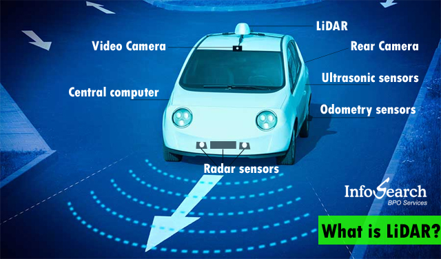
According to a recent statement from existing auto-tech producers, self-driving technology has reached a significant milestone. Recent advancements in their automation are the LiDAR annotation technology which enables them to identify objects from up to 400 meters away and even increase their low-light skills. But all of this invites us into a deeper insight on the question: what is LiDAR? Furthermore, how crucial is it to the car industry’s future?

What is exactly LiDAR?
LIDAR (Light Detection and Ranging) is the pinnacle of mapping technology. “Light Detection and Ranging,” or LiDAR, is a sensor technology that can produce a map of its surroundings. They create spinning cylindrical things that are visible on the car’s early automatic vehicles. Since then, they’ve gotten a lot more streamlined. For self-driving features, the maps provided by these devices are highly essential. Outside of the automobile sector, LiDAR is also employed on mobile devices. The range is less of an issue to enable augmented reality, distance measurement, and background blurring in photographs and videos.
What is the working mechanism of LiDAR?
For a self-driving vehicle, the map provided by a LiDAR sensor is crucial since it allows the car to “see” the environment around it. Other alternatives, such as radar and cameras, give information, but it’s really of significantly less depth and detail than LiDAR technology. It may be used at any time of the day or night.
However, LiDAR sensors were initially quite costly, rather than striking a few of them on consumer vehicles. But with this, a supplier or third-party company would go out with a small number of vehicles equipped with these sensors to create a map, then supply that detailed information to automakers, who would use it with their driver assistance features. It’s like a supplier would send a car out with a load of LiDAR sensors, which would then obtain a highly detailed map, similar to how Google sends out a vehicle with a tonne of cameras to acquire street view photographs.
What are the best LiDAR technology’s uses?
● LiDAR systems’ increasing power and mobility are being accepted as they are integrated into new and intriguing research roles, like in Hollywood productions, and – most importantly – in revolutionizing how we travel our highways.
● It’s been used by environmental organizations to measure tree development over vast ecosystems. For example, the LiDAR-equipped planes swoop overhead, cataloging billions of individual leaves and branches in a single sweep, even at cruising speed.
● NASA uses LiDAR to compute stratospheric temperature by monitoring the density of particular components in the atmosphere from afar. In contrast, environmental scientists use it to map the topography of the ocean floor.
● Transportation organizations have also used LiDAR to map highway systems and the infrastructure that surrounds them.
But the best of LiDAR’s applicability is seen in the innovative ideas of consumer car development. Let’s see!
LIDAR in automation of car technology
Radar has long been used in the car industry to manage speed, braking, and safety systems due to unexpected changes in traffic circumstances. But today, manufacturers are incorporating LiDAR into Advanced Driver Assistance Systems (ADAS) to see the constantly changing settings in which their vehicles operate. The abundance of data generated by the integration of automobile platforms can allow ADAS systems to make hundreds of calculated driving decisions every minute.
They’re using this cutting-edge technology as a foundation for creating new driver assistance features that will help us get closer to providing a truly completely autonomous car without compromising safety. Thus, keeping a high aim to fulfill the requirement of a self-driving system that is cautious and diligently and bravely developing this new paradigm.
Wrap Up!
Automation is new me to be employed for fleets of Robo-taxis or delivery vehicles for the time being. At the same time, there have been breakthroughs that suggest the technology might be applied in the transport business. The limitations and cost of these capabilities are becoming more accessible because of the ongoing advancement of LiDAR technology. So, a safe and thoughtful approach to accessing it shall for sure create the best of all without compromising anyone’s safety.
Infosearch can help your business with 3D LiDAR and Point Cloud Annotation and 16 more types of annotation support services. Write to us – enquiries(AT)infosearchbpo(DOT)com to discuss your requirements.


Recent Comments